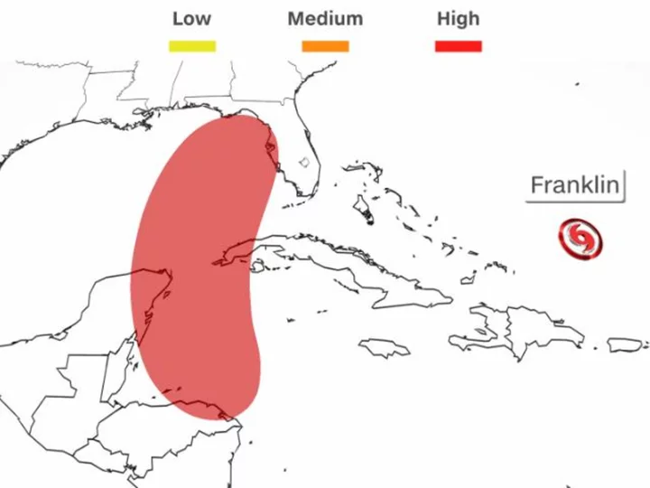
An area of showers and thunderstorms in the Caribbean Sea could develop into a tropical system as soon as Sunday, posing a risk to Florida and the Gulf of Mexico coast early next week.
Forecasters at the National Hurricane Center are watching the disturbed weather near Central America, which is expected to track north this weekend through the Caribbean Sea toward the Gulf of Mexico, where it could form the Atlantic Ocean's tenth tropical system this year.
A tropical depression or named storm could develop late this weekend or early next week if the currently disorganized showers and thunderstorms consolidate into one swirling mass with a defined center.
As of Friday morning, the National Hurricane Center said there is a high chance of this happening within the next seven days.
Who should pay attention? Nothing has formed yet, so it's too early to pinpoint an exact track. But Mexico's Yucatan Peninsula, Cuba and the northern Gulf and Florida coast should monitor the forecast in the coming days. The direction and strength of the upper-level steering winds around this system will dictate where it will move and how quickly.
How soon could it form? A tropical depression is likely to form within the next day or two.
When could it affect the US? If a tropical system does develop, it could affect the US as soon as Monday if it is pulled northward by strong steering winds. Weaker steering winds would lead to a slower track and impact midweek.
How strong could it get? It's still too soon to tell how strong this system could get -- or how fast it could strengthen. But it will be tracking through the warmest waters in the entire Atlantic basin -- a vast source of energy for a developing storm. Exceptionally warm water can provide storms the fuel needed to strengthen and sometimes undergo rapid intensification.
Sea surface temperatures are record warm in the Gulf of Mexico and extremely high across the northwestern Caribbean Sea. Water temperatures need to be around 80 degrees Fahrenheit to sustain tropical development, and portions of the Caribbean and Gulf are well above that threshold.
A hurdle to development: Warm water isn't the only factor at play. This potential tropical system would also need upper-level winds to cooperate. High wind shear -- the wind's change in direction or speed with altitude -- can tear a developing storm apart.
How much wind shear this potential system faces is a critical factor in its formation and final strength. One forecast model shows more wind shear, limiting its development. Another shows less wind shear, allowing the system to develop.
Either way, wind shear may decrease for a time early next week across the far northern Caribbean and eastern Gulf of Mexico, allowing any system that forms to hold together.
Franklin to strengthen and approach Bermuda
Meanwhile, out in the central Atlantic, Franklin is on track to pass near Bermuda as a hurricane after slamming Hispaniola with flooding rainfall and strong winds.
The storm will track away from Hispaniola and Turks and Caicos through Friday night before making a turn to the north on Saturday. The storm is expected to strengthen into a hurricane over the weekend as it enters an area of low wind shear and very warm water.
Small variations in Franklin's track through the weekend will determine exactly how close it gets to Bermuda when it make its closest pass Monday and Monday night.
Franklin's winds and rainfall will extend beyond its center. Tropical-storm-force wind gusts are possible across Bermuda early next week as Franklin makes its closest approach. A few showers and thunderstorms are also possible across Bermuda as Franklin passes.

