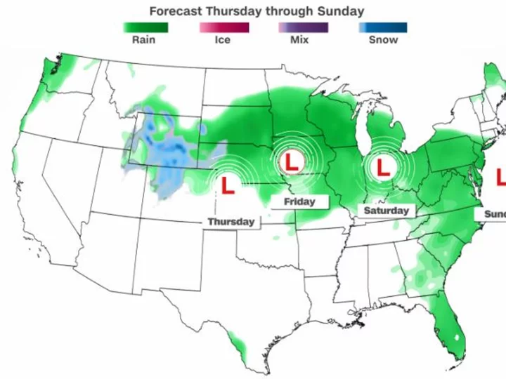
A powerful storm will traverse nearly 1,500 miles of the US through the weekend and unload snow, severe thunderstorms and flooding rain along its path, culminating in the eighth consecutive dreary weekend in parts of the Northeast.
The storm will dump the first significant snow of the season on parts of the Rockies, where low-elevation rain and high-elevation snow will continue through early Friday as the potent storm strengthens and tracks across the Plains.
Parts of Colorado, Utah, Montana and South Dakota could see 6 to 12 inches of snow. Snow totals in higher elevations in Wyoming may approach 1 to 2 feet.
While heavy snow falls in high elevations in the Rockies, heavy rain and thunderstorms -- some of which could become severe -- will target the Plains Thursday.
The highest chance for severe thunderstorms will be from Thursday afternoon into Thursday night in parts of Kansas, Nebraska, Missouri and Iowa, where a Level 2 out of 5 risk is in place. Large hail and damaging wind gusts are the primary threats, but a couple of tornadoes are also possible.
Heavy rain will accompany some severe thunderstorms, but drenching rainfall will not be limited to those storms. Widespread rainfall totals of 1 to 3 inches are possible Thursday and Thursday night across parts of Minnesota and Wisconsin.
Rain and thunderstorms will shift east on Friday and expand across more of the Mississippi Valley and the Midwest.
Another 1 to 3 inches of rain is possible in areas caught in the heaviest storms. Wisconsin, Michigan, Indiana and Illinois are just a few states set for a soaking on Friday.
The rain will help the drought-stricken Mississippi Valley and the historically low water levels on the Mississippi River. Following a dry and exceptionally hot summer, drought is present in every state in the Mississippi Valley and portions of the Plains. Exceptional drought -- the most severe level of drought tracked by the US Drought Monitor -- is in place across parts of Nebraska, Kansas and Iowa.
Rainfall this week across the upper Mississippi River basin will eventually work its way into the river and cause slight rises in water levels by the end of October and early November, which could also help stymie the wedge of saltwater threatening drinking water in southern Louisiana.
By Saturday, rain from the storm will spread into the Northeast and persist in the Midwest. The rain will make for yet another dreary weekend for parts of the region. Rain has fallen in the area almost like clockwork every weekend for some locations since the end of August. This could be the eighth consecutive weekend of rain for Philadelphia and the sixth consecutive for New York City.
An inch or two of rain is possible across portions of Pennsylvania, New Jersey and New York on Saturday, while parts of southern New England may skate through the weekend with under an inch of rain.
Rainfall is expected to ease up early Sunday and some of the Northeast may even dry out completely by Sunday afternoon.

