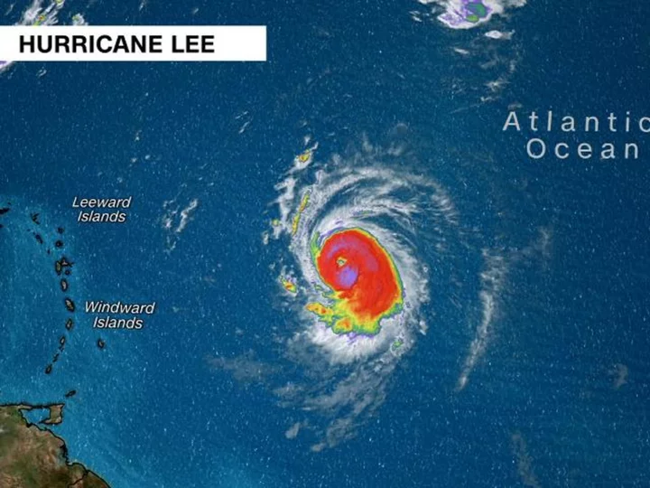
Hurricane Lee has strengthened into a major Category 5 storm, packing maximum sustained wind speeds of 160 mph as it spins over the Atlantic well east of the Caribbean, the National Hurricane Center said in an 11 p.m. ET advisory Thursday.
Lee, which was a Category 1 storm earlier Thursday, has been intensifying with exceptional speed in warm ocean waters, doubling its wind speeds in the last 24 hours.
The hurricane was located about 700 miles east of the northern Leeward Islands, the hurricane center said in the 11 p.m. advisory.
The storm will likely reach its peak intensity by this weekend and is still expected to be a dangerous hurricane over the southwestern Atlantic early next week, though it's too soon to know whether this system will directly impact the US mainland.
Dangerous surf and rip currents will spread across the northern Caribbean on Friday and begin affecting the US on Sunday, the center said.
There is increasing confidence that the center of Lee will pass to the north of the Leeward Islands, the Virgin Islands and Puerto Rico this weekend and into early next week. Tropical storm conditions, life-threatening surf and rip currents could occur on some of these islands over the weekend.
Computer model trends for Lee have shown the hurricane taking a turn to the north early next week. But exactly when that turn occurs and how far west Lee will manage to track by then will play a huge role in how close it gets to the US.
Here's what will steer the storm and two potential scenarios meteorologists are watching for how the US threat could play out.
How close will Hurricane Lee get to the US?
Several steering factors at the surface and upper levels of the atmosphere will determine how close Lee will get to the East Coast.
An area of high pressure over the Atlantic, known as the Bermuda High, will have a major influence in how quickly Lee turns. The Bermuda High is expected to remain very strong into the weekend, which will keep Lee on its current west-northwestward track and slow it down a bit.
As the high pressure weakens next week it will allow Lee to start moving northward.
Once that turn to the north occurs, the position of the jet stream -- strong upper-level winds that can change the direction of a hurricane's path -- will influence how closely Lee is steered to the US.
Scenario: Out to Sea
Lee could make a quick turn to the north early next week if high pressure weakens significantly.
If the jet stream sets up along the East Coast, it will act as a barrier that prevents Lee from approaching the coast. This scenario would keep Lee farther away from the US coast but could bring the storm closer to Bermuda.
Scenario: Close to East Coast
Lee could make a slower turn to the north because the high pressure remains robust, and the jet stream sets up farther inland over the Eastern US. This scenario would leave portions of the East Coast, mainly north of the Carolinas, vulnerable to a much closer approach from Lee.
All these factors have yet to come into focus, and the hurricane is still at least seven days from being a threat to the East Coast. Any potential US impact will become more clear as the Lee moves west in the coming days.
Several storms in open waters
As Lee churns in the Atlantic, another storm was named after intensifying in open ocean waters.
On Thursday, a tropical depression in the eastern Atlantic strengthened into Tropical Storm Margot, just a few hundred miles west of the Cabo Verde Islands, the center said.
Margot currently has winds of 40 mph and steady strengthening is expected -- the center is forecasting Margot to become a hurricane over the weekend. The forecast track shows the storm turning to the north over the central Atlantic early next week, but it is not expected to threaten any land areas as of Thursday.
In the northern Pacific, Hurricane Jova remains a major hurricane, albeit far from any possible shorelines, roughly 650 miles west-southwest from the southern tip of the Baja California peninsula, according to the National Hurricane Center Thursday night.
Now a Category 3 storm after reaching Category 5 strength earlier, Jova has maximum sustained winds of 125 mph as of late Thursday, the hurricane center said, while "continued weakening is forecast during the next several days."

